


Randonnée la Vineuse 22/04/2019

ash
User
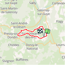

Length
16.7 km

Max alt
369 m

Uphill gradient
390 m
Km-Effort
22 km

Min alt
226 m

Downhill gradient
393 m
Boucle
Yes
Creation date :
2019-04-22 08:38:24.0
Updated on :
2019-04-22 12:24:38.626
3h30
Difficulty : Medium

FREE GPS app for hiking
 SityTrail
IGN / Geographical institutes
SityTrail Plus
The world is yours!
About
Trail Walking of 16.7 km to be discovered at Bourgogne-Franche-Comté, Saône-et-Loire, La Vineuse sur Fregande. This trail is proposed by ash.
Description
Randonnée du 22/04/2019 16kms
Positioning
Country:
France
Region :
Bourgogne-Franche-Comté
Department/Province :
Saône-et-Loire
Municipality :
La Vineuse sur Fregande
Location:
Unknown
Start:(Dec)
Start:(UTM)
622624 ; 5147720 (31T) N.
Comments